Hydroacoustics
MaxDepth Aquatics uses the latest in BioSonics hydroacoustic equipment linked with
Trimble DGPS for analysis of bathymetry, substrate classification, macrophyte
delineation, and fisheries assessment. These four elements form the basic suite of data inputs
for aquatic habitat characterization. Within each of these major groups, there are components of the analyses that can be tailored
to specific applications as described below:
Bathymetry
Knowledge
of
the
amount
of
water
and
depths
in
any
aquatic
system
is
essential
for
management
of
the
water
quantity
and
water
quality.
The
intensity
of
the
survey
effort
can
be
adjusted
to
accommodate
a
variety
of
needs
ranging
from
simple
exploratory
maps
to
high-resolution
bathymetry
of
specific
features
of
a
system.
Shown
below
on the left is a high resolution image of the channel excavated at the outlet of
Diamond
Lake,
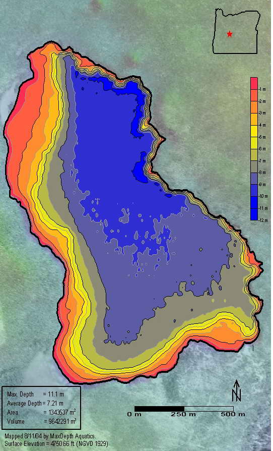
Oregon in 1954 to lower the lake stage prior to treatment with rotenone. The bathymetry map on the right is of Lava Lake, Oregon. A general discussion on the value of bathymetry maps is presented in the article by Eilers (2004).


Substrate
Classification
The
echoes
generated
from
the
hydroacoustic
signal
provide
information
regarding
the
regularity
and
reflectivity
of
the
substrate.
These
signals
can
be
assessed
separately
or
as
a
statistical
combination
to
provide
an
indication
of
the
nature
of
the
substrate.
Unsupervised
classifications
of
substrate
composition
can
be
further
refined
by
collecting
sediment
samples
in
the
study
domain
to
develop
supervised
classifications
of
the
substrate
such
as
organic
detritus,
sand,
cobble,
and
vegetation.

Macrophyte
Delineation
The
hydroacoustic
surveys
are
extremely
valuable
for
locating
the
spatial
extent,
canopy
height,
and
density
of
submerged
macrophytes.
As
with
the
substrate
classifications,
the
macrophyte
mapping
can
be
further
enhanced
through
the
use
of
a
designed
macrophyte
sampling
program
to
generate
macrophyte
maps
that
illustrate
spatial
patterns
among
taxa.

Fisheries
Assessment
Hydroacoustics
provides
precise
information
regarding
the
spatial
distribution
of
fish
within
lakes,
reservoirs
and
estuaries.
The
hydroacoustics
can
be
deployed
in
an
exploratory
fashion
to
develop
an
information
base
on
fish
locations
in
previously unsurveyed
waters
or
can
be
used
in
a
rigorous
sampling
design
over
prescribed
tracks
to
quantify
the
abundance
of
fish
and
their
size
distribution.
Repeated
surveys
in
multiple
seasons
aid
in
better
understanding
the
use
of
various
habitats
and
fish
behaviors
under
spawning
and
feeding
conditions.
Again,
the
fisheries
assessment
with
hydroacoustics
can
be
complemented
by
simultaneous
use
of
traditional
netting
techniques
to
provide
verification
of
the
observed
targets and to better sample in shallow, weedy areas of lakes.

Odell Lake. The large aggregations of fish appear to be kokanee schooled up in the day.

Odell Lake. Same transect viewed at night showing the dispersal of fish.


 MaxDepth Aquatics, Inc.